Cuenta atrás Contador|Contador de tiempo
English
Français
Deutsch
Español
日本語
繁體
简体
Português
Italiano
Русский
हिन्दी
ไทย
Indonesia
Filipino
Nederlands
Dansk
Svenska
Norsk
Ελληνικά
Polska
Türkçe
العربية
Cuenta atrás
Contador|Contador de tiempo
Cuenta atrás
Contador|Contador de tiempo
Cuenta atrás
nacimiento de tu bebé
New Toy
Fecha de parto
Día de San Valentín
Día de las Madres
Participación
Aniversario
Cumpleaños
Fiesta
Boda
ir a casa
Vacaciones Cuenta atrás
Fiesta
Exámenes
18 años de edad
Jubilación
Dejando
egreso a la Escuela
Graduación
Ir al extranjero
Viajar
Apertura
Apertura
Reunión
Conferencia
Concierto
Teatro
Elecciones
Campeonato
Visita
Navidad
Super Bowl
FIFA
Año Nuevo
Año Nuevo Chino
Año Nuevo Cards
Wedding Card
Holiday Card
Printing Card
Primavera
Verano
Otoño
Invierno
Kids Song
Contador|Contador de tiempo
Amor
He Been Loving You
Yo he vivido
Nuestro matrimonio dura
He estado aquí
Nos hemos reunido
Campeonato Cuenta atrás|Contador|Contador de tiempo
Cuenta atrás|Contador|Contador de tiempo Herramienta!
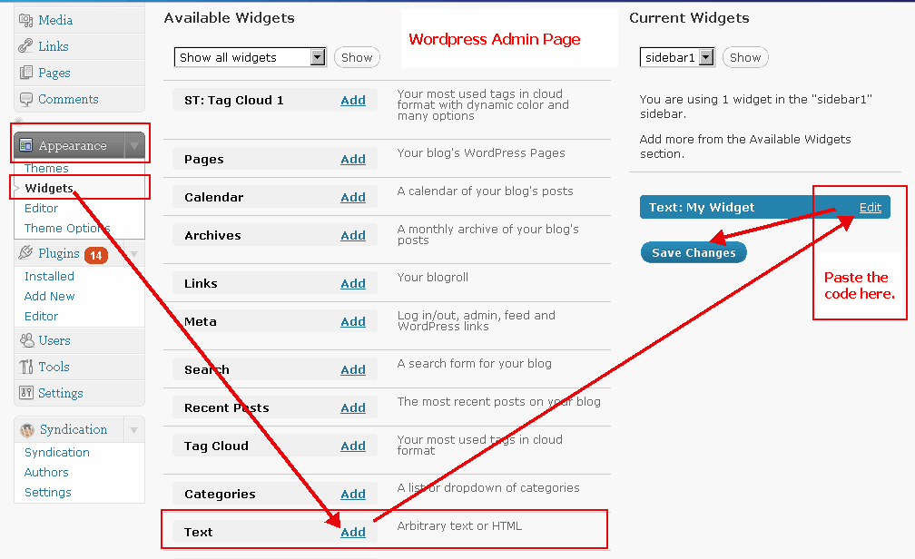
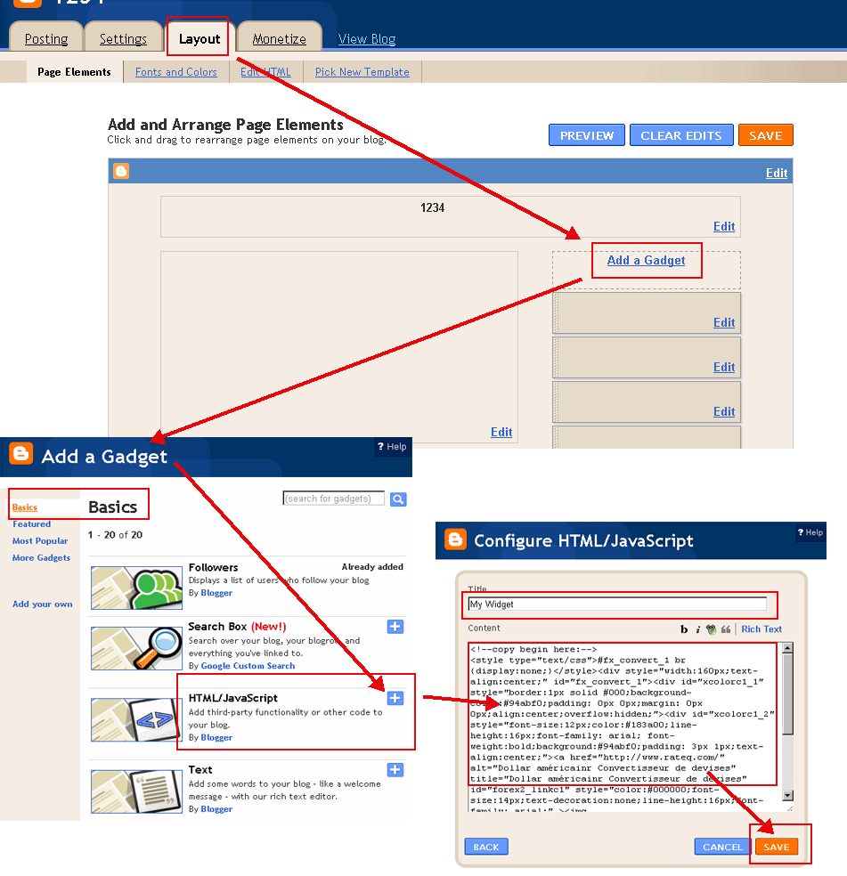
Pulse el botón copiar y pegar en tu blog o sitio web.
(Por favor, cambiar a 'HTML' al modo de desplazamiento en su blog. Ejemplos:
Ejemplo WordPress
,
Ejemplo Blogger
)
Fecha (año-mes-día):
Texto:
Seleccione Color(
?
):
Color de fuente(
?
):
Campeonato
Copiar al portapapeles
<!--copy begin here:--> <style type="text/css">#fx_convert_1 br {display:none;}</style><div style="width:190px;text-align:center;" id="fx_convert_1"><div id="xcolorc1_1" style="border:1px solid #000;background-color:#94abf0;padding: 0px 0px;margin: 0px 0px;align:center;overflow:hidden;"><div id="xcolorc1_2" style="font-size:12px;color:#183a00;line-height:16px;font-family: arial; font-weight:bold;background:#94abf0;padding: 3px 1px;text-align:center;"><a href="http://es.freecountdown.net/Campeonato" alt="Campeonato | Cuenta atrás|Contador|Contador de tiempo" title="Campeonato | Cuenta atrás|Contador|Contador de tiempo" id="xcount_link1" style="color:#111111;font-size:14px;text-decoration:none;line-height:16px;font-family: arial;" >Campeonato</a></div><div id="xcount1_1964686378" style="font-size: 1em;font-family: arial; font-weight:bold"></div><script src="http://es.freecountdown.net/z.php?text=&t=1&fd=2026-08-06&dir=down&id=1_1964686378&fc=111111"></script></div></div> <!--copy end here:-->
Campeonato
Copiar al portapapeles
<!--copy begin here:--> <style type="text/css">#fx_convert_1 br {display:none;}</style><div style="width:300px;text-align:center;" id="fx_convert_1"><div id="xcolorc2_1" style="border:1px solid #000;background-color:#94abf0;padding: 0px 0px;margin: 0px 0px;align:center;overflow:hidden;"><div id="xcolorc2_2" style="font-size:12px;color:#183a00;line-height:16px;font-family: arial; font-weight:bold;background:#94abf0;padding: 3px 1px;text-align:center;"><a href="http://es.freecountdown.net/Campeonato" alt="Campeonato | Cuenta atrás|Contador|Contador de tiempo" title="Campeonato | Cuenta atrás|Contador|Contador de tiempo" id="xcount_link2" style="color:#111111;font-size:14px;text-decoration:none;line-height:16px;font-family: arial;" >Campeonato</a></div><div id="xcount2_210018493" style="font-size: 1em;font-family: arial; font-weight:bold"></div><script src="http://es.freecountdown.net/z.php?text=&t=2&fd=2026-08-06&dir=down&id=2_210018493&fc=111111"></script></div></div> <!--copy end here:-->
Campeonato
Copiar al portapapeles
<!--copy begin here:--> <style type="text/css">#fx_convert_1 br {display:none;}</style><div style="width:190px;text-align:center;" id="fx_convert_1"><div id="xcolorc3_1" style="border:1px solid #000;background-color:#94abf0;padding: 0px 0px;margin: 0px 0px;align:center;overflow:hidden;"><div id="xcolorc3_2" style="font-size:12px;color:#183a00;line-height:16px;font-family: arial; font-weight:bold;background:#94abf0;padding: 3px 1px;text-align:center;"><script src="http://es.freecountdown.net/z.php?text=&t=3&fd=2026-08-06&dir=down&id=3_1276357084&fc=111111"></script></div><div id="xcount3_1276357084" style="font-size: 1em;font-family: arial; font-weight:bold"></div><div style="font-size:12px;color:#183a00;line-height:16px;font-family: arial; font-weight:bold;padding: 3px 1px;text-align:center;"><a href="http://es.freecountdown.net/Campeonato" alt="Campeonato | Cuenta atrás|Contador|Contador de tiempo" title="Campeonato | Cuenta atrás|Contador|Contador de tiempo" id="xcount_link3" style="color:#111111;font-size:14px;text-decoration:none;line-height:16px;font-family: arial;" >Campeonato</a></div></div></div> <!--copy end here:-->
Campeonato
Copiar al portapapeles
<!--copy begin here:--> <style type="text/css">#fx_convert_1 br {display:none;}</style><div style="width:300px;text-align:center;" id="fx_convert_1"><div id="xcolorc4_1" style="border:1px solid #000;background-color:#94abf0;padding: 0px 0px;margin: 0px 0px;align:center;overflow:hidden;"><div id="xcolorc4_2" style="font-size:12px;color:#183a00;line-height:16px;font-family: arial; font-weight:bold;background:#94abf0;padding: 3px 1px;text-align:center;"><script src="http://es.freecountdown.net/z.php?text=&t=4&fd=2026-08-06&dir=down&id=4_293107753&fc=111111"></script></div><div id="xcount4_293107753" style="font-size: 1em;font-family: arial; font-weight:bold"></div><div style="font-size:12px;color:#183a00;line-height:16px;font-family: arial; font-weight:bold;padding: 3px 1px;text-align:center;"><a href="http://es.freecountdown.net/Campeonato" alt="Campeonato | Cuenta atrás|Contador|Contador de tiempo" title="Campeonato | Cuenta atrás|Contador|Contador de tiempo" id="xcount_link4" style="color:#111111;font-size:14px;text-decoration:none;line-height:16px;font-family: arial;" >Campeonato</a></div></div></div> <!--copy end here:-->
Cuenta atrás|Contador|Contador de tiempo Herramienta:
Campeonato Información y Noticias: